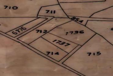
General Boundary (Mutation) Surveys involve the precise surveying and documentation of land boundaries when a property changes hands or undergoes modification, such as after a sale, inheritance, or division. The survey updates the land ownership records (mutation records) with new boundary details to match the reality on the ground. This process is critical for maintaining clear property rights, avoiding disputes, and ensuring that government and cadastral (land registration) databases remain accurate and current. Typically conducted by licensed surveyors, General Boundary (Mutation) Surveys include identifying existing boundary markers, measuring plots using modern equipment, preparing detailed site plans, and submitting updated reports to land authorities for legal registration
General Boundary (Mutation) Surveys
Service Description
Related Services
Featured
Land conveyancing is the legal and administrative process involved in transferri...
Featured
Due Diligence Surveys are critical investigations conducted before buying, selli...
Featured
Topographical surveys are detailed surveys that capture and represent the three-...