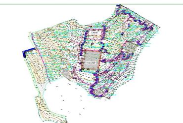
Topographical surveys are detailed surveys that capture and represent the three-dimensional features of a land surface. They record both natural features like hills, rivers, trees, and valleys, and man-made structures such as roads, buildings, fences, and utilities. These surveys are essential for planning construction projects, infrastructure development, landscaping, and land assessment. Topographical surveys provide precise data on elevation changes, slope, and contours, which help architects, engineers, and planners design according to the land’s actual conditions. Modern topographical surveys use tools like Total Stations, GPS equipment, drones, and 3D laser scanners to create accurate maps and digital models.
Topographical surveys
Service Description
Related Services

Featured
Land conveyancing is the legal and administrative process involved in transferri...

Featured
Due Diligence Surveys are critical investigations conducted before buying, selli...
Featured
Subdivisions and amalgamations are land management processes that change the str...