
Blog
Boundary disputes in Kenya and the Crucial Role of a Surveyor
-

Meridian Mapping
- May 12, 2025
During colonial times, large tracts of land were parceled out for indigenous communities through a process known as land adjudication. The boundaries were determined through existing fences and agreed-upon boundaries and natural features such as rivers, which given their nature, have shifted over the years. The land was also communally owned, and as such, even after independence, the transition to private ownership was not always smooth.
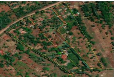
Given that these surveys were conducted before digital records were established, many older parcels of land lack proper surveying records or have outdated maps that do not reflect how the land is currently being used. As a result, when the reference data (map) is missing, dispute arise.
In connection to this, in several counties, notoriously Kajiado and Nyandarua, new subdivisions are often not amended on the maps, giving land owners and also surveyors a hard time in establishing boundaries thus resulting in errors and consequently disputes.
In many families, land is divided formally among heirs without formal subdivision or updating of titles, which of course results in overlaps and confusion over the actual boundaries.
Disputes also abound due to fraudulent land sales and double allocations which cause multiple parties to claim the same piece of land.

Leave a Comment